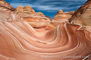
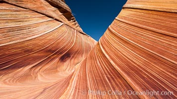
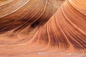
The Wave, North Coyote Buttes.
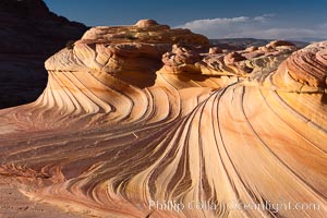
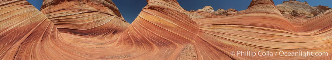
The Second Wave, North Coyote Buttes, Paria Canyon-Vermilion Cliffs Wilderness.
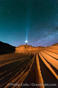
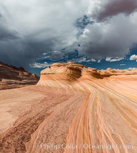
The Second Wave at Night. The Second Wave, a spectacular sandstone formation in the North Coyote Buttes, lies under a sky full of stars.
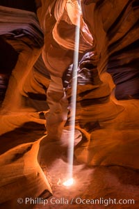
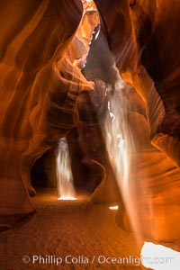
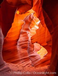
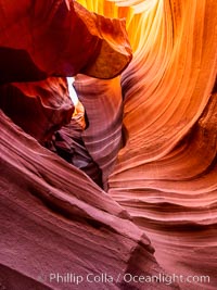
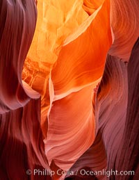
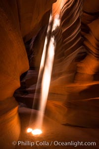
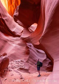
Light Beam in Upper Antelope Slot Canyon. Thin shafts of light briefly penetrate the convoluted narrows of Upper Antelope Slot Canyon, sending piercing beams through the sandstone maze to the sand floor below.
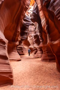
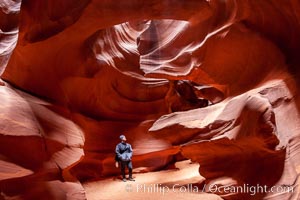
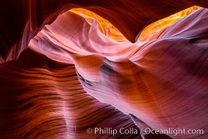
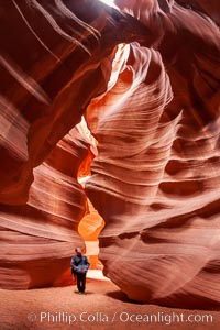
A hiker admiring the striated walls and dramatic light within Antelope Canyon, a deep narrow slot canyon formed by water and wind erosion.
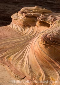
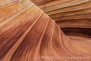
The Second Wave at Sunset, Vermillion Cliffs. The Second Wave, a curiously-shaped sandstone swirl, takes on rich warm tones and dramatic shadowed textures at sunset. Set in the North Coyote Buttes of Arizona and Utah, the Second Wave is characterized by striations revealing layers of sedimentary deposits, a visible historical record depicting eons of submarine geology
The Second Wave at sunset. The Second Wave, a curiously-shaped sandstone swirl, takes on rich warm tones and dramatic shadowed textures at sunset. Set in the North Coyote Buttes of Arizona and Utah, the Second Wave is characterized by striations revealing layers of sedimentary deposits, a visible historical record depicting eons of submarine geology

Male Northern cardinal, Cardinalis cardinalis, Arizona
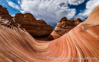
The Wave in the North Coyote Buttes, an area of fantastic eroded sandstone featuring beautiful swirls, wild colors, countless striations, and bizarre shapes set amidst the dramatic surrounding North Coyote Buttes of Arizona and Utah. The sandstone formations of the North Coyote Buttes, including the Wave, date from the Jurassic period. Managed by the Bureau of Land Management, the Wave is located in the Paria Canyon-Vermilion Cliffs Wilderness and is accessible on foot by permit only.
Sandstone swirls at The Wave, North Coyote Buttes.
Panorama of the Wave, North Coyote Buttes, Arizona.
Light Beam in Upper Antelope Slot Canyon. Thin shafts of light briefly penetrate the convoluted narrows of Upper Antelope Slot Canyon, sending piercing beams through the sandstone maze to the sand floor below.
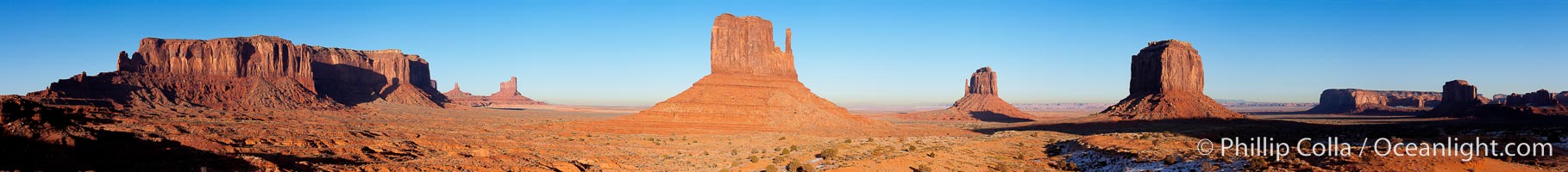
Monument Valley panorama, a composite of twelve individual photographs.

Male Pyrrhuloxia, Cardinalis sinuatus, Arizona.

Greater roadrunner, Geococcyx californianus, Arizona.

Black-headed grosbeak, male. Madera Canyon Recreation Area, Green Valley, Arizona. Pheucticus melanocephalus.
Slot canyons are formed when water and wind erode a cut through a (usually sandstone) mesa. Lower Antelope Canyon, Arizona.
Antelope Canyon, slot canyon exploring and hiking, canyoneering.
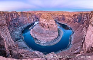
Belt of Venus over Horseshoe Bend on the Colorado River. The Colorado River makes a 180-degree turn at Horseshoe Bend. Here the river has eroded the Navajo sandstone for eons, digging a canyon 1100-feet deep. The Belt of Venus, or anti-twilight arch, is the shadow of the earth cast upon the atmosphere just above the horizon, and occurs a few minutes before sunrise or after sunset.
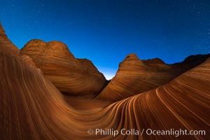
The Wave at Night, under a clear night sky full of stars. The Wave, an area of fantastic eroded sandstone featuring beautiful swirls, wild colors, countless striations, and bizarre shapes set amidst the dramatic surrounding North Coyote Buttes of Arizona and Utah. The sandstone formations of the North Coyote Buttes, including the Wave, date from the Jurassic period. Managed by the Bureau of Land Management, the Wave is located in the Paria Canyon-Vermilion Cliffs Wilderness and is accessible on foot by permit only.
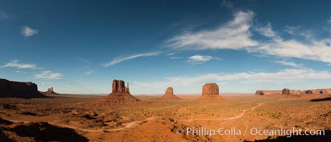
Monument Valley panorama
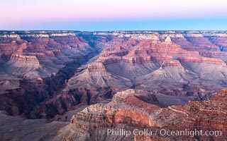
Belt of Venus over Grand Canyon at sunrise, viewed from Hopi Point on the south rim of Grand Canyon National Park. The Belt of Venus, or anti-twilight arch, is the shadow of the earth cast upon the atmosphere just above the horizon, and occurs a few minutes before sunrise or after sunset.
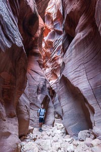
Lower Antelope Canyon, a deep, narrow and spectacular slot canyon lying on Navajo Tribal lands near Page, Arizona
Lower Antelope Canyon, a deep, narrow and spectacular slot canyon lying on Navajo Tribal lands near Page, Arizona
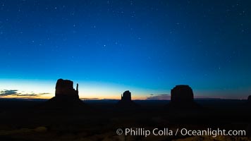
Monument Valley panorama, sunrise, dawn, stars in the sky.
The Wave in the North Coyote Buttes, an area of fantastic eroded sandstone featuring beautiful swirls, wild colors, countless striations, and bizarre shapes set amidst the dramatic surrounding North Coyote Buttes of Arizona and Utah. The sandstone formations of the North Coyote Buttes, including the Wave, date from the Jurassic period. Managed by the Bureau of Land Management, the Wave is located in the Paria Canyon-Vermilion Cliffs Wilderness and is accessible on foot by permit only.
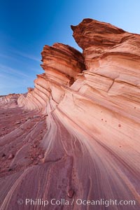
The Great Wall, Navajo Tribal Lands, Arizona. Sandstone ""fins"", eroded striations that depict how sandstone -- ancient compressed sand -- was laid down in layers over time. Now exposed, the layer erode at different rates, forming delicate ""fins"" that stretch for long distances.
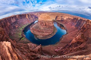
Horseshoe Bend. The Colorado River makes a 180-degree turn at Horseshoe Bend. Here the river has eroded the Navajo sandstone for eons, digging a canyon 1100-feet deep.
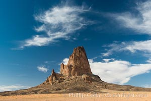
Agaltha Peak, also know as El Capitan Peak, rises to over 1500' in height near Kayenta, Arizona and Monument Valley. Agathla Peak is an eroded volcanic plug consisting of volcanic breccia cut by dikes of an unusual igneous rock called minette.
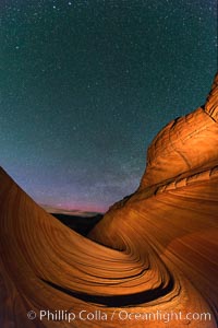
The Wave at Night, under a clear night sky full of stars. The Wave, an area of fantastic eroded sandstone featuring beautiful swirls, wild colors, countless striations, and bizarre shapes set amidst the dramatic surrounding North Coyote Buttes of Arizona and Utah. The sandstone formations of the North Coyote Buttes, including the Wave, date from the Jurassic period. Managed by the Bureau of Land Management, the Wave is located in the Paria Canyon-Vermilion Cliffs Wilderness and is accessible on foot by permit only.
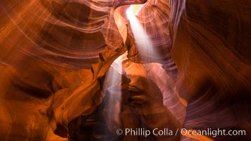
Light Beam in Upper Antelope Slot Canyon. Thin shafts of light briefly penetrate the convoluted narrows of Upper Antelope Slot Canyon, sending piercing beams through the sandstone maze to the sand floor below.
The Wave in the North Coyote Buttes, an area of fantastic eroded sandstone featuring beautiful swirls, wild colors, countless striations, and bizarre shapes set amidst the dramatic surrounding North Coyote Buttes of Arizona and Utah. The sandstone formations of the North Coyote Buttes, including the Wave, date from the Jurassic period. Managed by the Bureau of Land Management, the Wave is located in the Paria Canyon-Vermilion Cliffs Wilderness and is accessible on foot by permit only.
Lower Antelope Canyon, a deep, narrow and spectacular slot canyon lying on Navajo Tribal lands near Page, Arizona
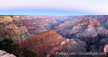
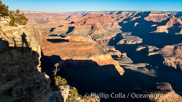
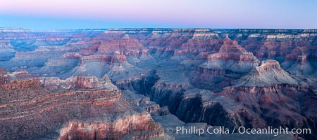
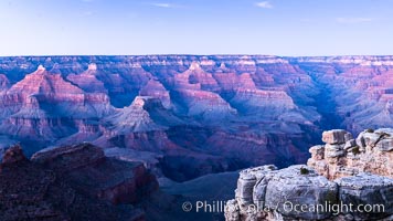
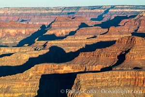
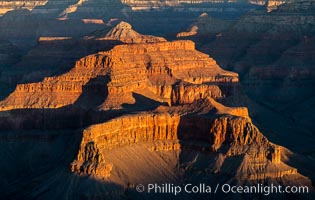
Grand Canyon at dusk, sunset, viewed from Mather Point on the south rim of Grand Canyon National Park
Belt of Venus over Grand Canyon at dusk, sunset, viewed from Mather Point on the south rim of Grand Canyon National Park. The Belt of Venus, or anti-twilight arch, is the shadow of the earth cast upon the atmosphere just above the horizon, and occurs a few minutes before sunrise or after sunset.
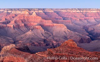
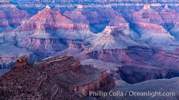
Grand Canyon at sunrise viewed from Yavapai Point on the south rim of Grand Canyon National Park
Grand Canyon at sunrise viewed from Yavapai Point on the south rim of Grand Canyon National Park
Grand Canyon at dusk, sunset, viewed from Grandeur Point on the south rim of Grand Canyon National Park
Lower Antelope Canyon, a deep, narrow and spectacular slot canyon lying on Navajo Tribal lands near Page, Arizona.
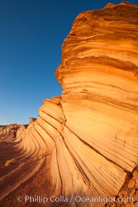
The Great Wall. Sunset on sandstone fins, Navajo Tribal Lands, Arizona.
Light Beam in Upper Antelope Slot Canyon. Thin shafts of light briefly penetrate the convoluted narrows of Upper Antelope Slot Canyon, sending piercing beams through the sandstone maze to the sand floor below.
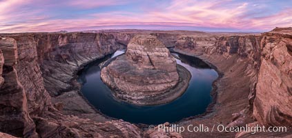
Spectacular Horseshoe Bend sunrise. The Colorado River makes a 180-degree turn at Horseshoe Bend. Here the river has eroded the Navajo sandstone for eons, digging a canyon 1100-feet deep
Grand Canyon at dusk, sunset, viewed from Grandeur Point on the south rim of Grand Canyon National Park
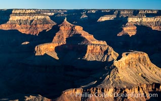
Grand Canyon at sunrise viewed from Yavapai Point on the south rim of Grand Canyon National Park
Grand Canyon at sunrise viewed from Yavapai Point on the south rim of Grand Canyon National Park
Grand Canyon at sunrise, viewed from Hopi Point on the south rim of Grand Canyon National Park
Hiker in Buckskin Gulch, Vermilion Cliffs National Monument, Arizona.
Lower Antelope Canyon, a deep, narrow and spectacular slot canyon lying on Navajo Tribal lands near Page, Arizona.
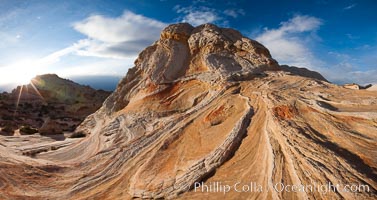
Sarah's Swirl, a particularly beautiful formation at White Pocket in the Vermillion Cliffs National Monument.
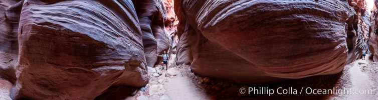
Panorama of a hiker in Buckskin Gulch, Paria Canyon-Vermilion Cliffs Wilderness, Arizona.
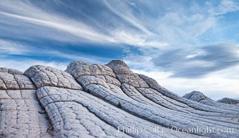
Brain rocks and clouds, White Pocket, Vermillion Cliffs National Monument, Arizona.
The Lollipop, White Pocket, Vermilion Cliffs National Monument.
Hiking and photographing, Lower Antelope Canyon, Page, Arizona.
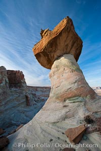
Stud Horse Point hoodoo, Arizona.
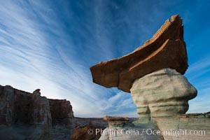
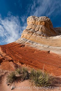
Pedestal rock, or hoodoo, at Stud Horse Point. These hoodoos form when erosion occurs around but not underneath a more resistant caprock that sits atop of the hoodoo spire.
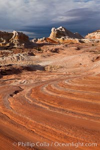
Sandstone and storm clouds, White Pocket, Arizona.
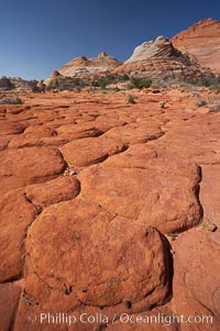
Geometric joints and cracks form in eroding sandstone, North Coyote Buttes, Arizona.
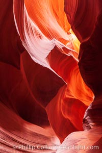
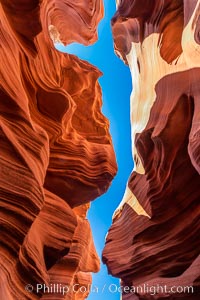
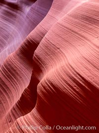
Scalloped walls and striated sandstone, water erosion, deep narrow slot canyon, Southwest.
Inside the entrance to Antelope Canyon Slot Canyon, striated walls and light beams, Page, Arizona.
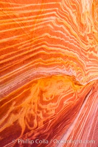
Brilliant sandstone patterns, The Wave, Arizona.

Desert cottontail rabbit, or Audubon's cottontail rabbit, Sylvilagus audubonii, Arizona.