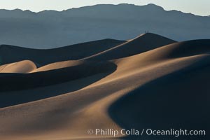
Tiny hikers atop Sand Dunes in Death Valley National Park, California. Near Stovepipe Wells lies a region of sand dunes, some of them hundreds of feet tall.
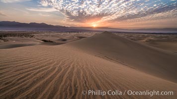
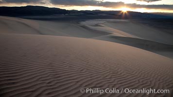
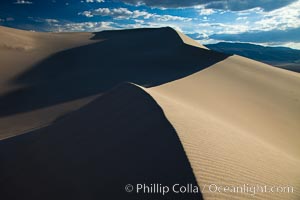
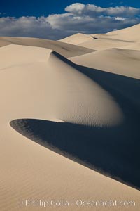
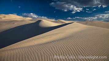
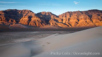
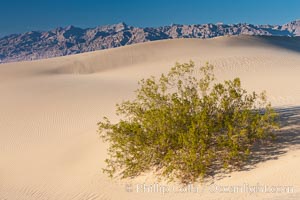
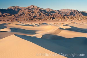
Mesquite Dunes sunrise, dawn, clouds and morning sky, sand dunes.
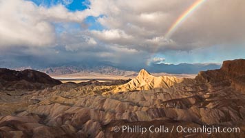
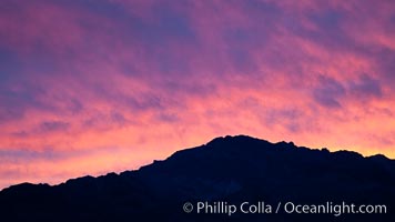
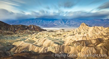
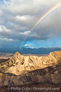
Rainbow and clearing storm clouds, sunrise light on Manly Beacon, Zabriskie Point, Death Valley National Park, California.
Mesquite Dunes sunrise, dawn, clouds and morning sky, sand dunes.
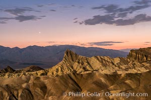
Venus sets over Manley Beacon and the Panamint Mountains, viewed from Zabriskie Point, landscape lit by a full moon, evening, stars
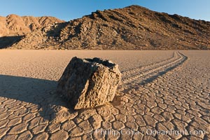
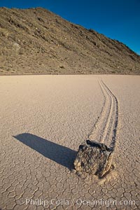
Sailing stone on the Racetrack Playa. The sliding rocks, or sailing stones, move across the mud flats of the Racetrack Playa, leaving trails behind in the mud. The explanation for their movement is not known with certainty, but many believe wind pushes the rocks over wet and perhaps icy mud in winter
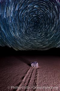
Racetrack sailing stone and star trails. A sliding rock of the Racetrack Playa. The sliding rocks, or sailing stones, move across the mud flats of the Racetrack Playa, leaving trails behind in the mud. The explanation for their movement is not known with certainty, but many believe wind pushes the rocks over wet and perhaps icy mud in winter
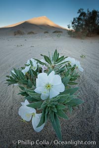
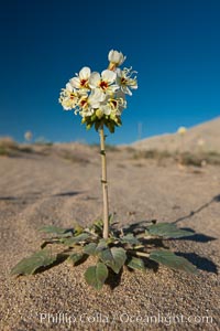
Eureka Valley Dune Evening Primrose. A federally endangered plant, Oenothera californica eurekensis is a perennial herb that produces white flowers from April to June. These flowers turn red as they age. The Eureka Dunes evening-primrose is found only in the southern portion of Eureka Valley Sand Dunes system in Indigo County, California.
Sunset on the Last Chance Mountain Range, seen from Eureka Valley Sand Dunes.
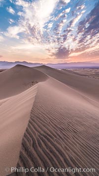
Mesquite Dunes sunrise, dawn, clouds and morning sky, sand dunes.
Racetrack Playa, an ancient lake now dried and covered with dessicated mud.
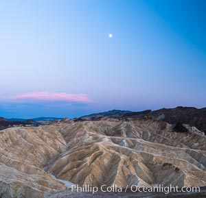
Full moon over Zabriskie Point landscape
Eureka Dunes. The Eureka Valley Sand Dunes are California's tallest sand dunes, and one of the tallest in the United States. Rising 680' above the floor of the Eureka Valley, the Eureka sand dunes are home to several endangered species, as well as ""singing sand"" that makes strange sounds when it shifts. Located in the remote northern portion of Death Valley National Park, the Eureka Dunes see very few visitors.
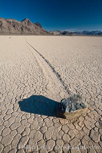
A sliding rock of the Racetrack Playa. The sliding rocks, or sailing stones, move across the mud flats of the Racetrack Playa, leaving trails behind in the mud. The explanation for their movement is not known with certainty, but many believe wind pushes the rocks over wet and perhaps icy mud in winter.
Sunset on the Eureka Dunes. The Eureka Valley Sand Dunes are California's tallest sand dunes, and one of the tallest in the United States. Rising 680' above the floor of the Eureka Valley, the Eureka sand dunes are home to several endangered species, as well as ""singing sand"" that makes strange sounds when it shifts. Located in the remote northern portion of Death Valley National Park, the Eureka Dunes see very few visitors.
Eureka Dunes. The Eureka Valley Sand Dunes are California's tallest sand dunes, and one of the tallest in the United States. Rising 680' above the floor of the Eureka Valley, the Eureka sand dunes are home to several endangered species, as well as ""singing sand"" that makes strange sounds when it shifts. Located in the remote northern portion of Death Valley National Park, the Eureka Dunes see very few visitors.
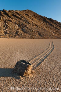
Sailing stone on the Racetrack Playa. The sliding rocks, or sailing stones, move across the mud flats of the Racetrack Playa, leaving trails behind in the mud. The explanation for their movement is not known with certainty, but many believe wind pushes the rocks over wet and perhaps icy mud in winter
Spring wildflower blooms on the Eureka sand dunes.
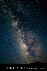
The Milky Way Galaxy, galactic center rising over Death Valley.
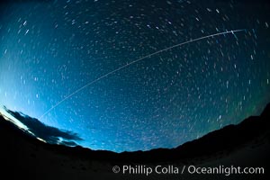
The International Space Station flys over Death Valley shortly after sunset.
Eureka Dunes. The Eureka Valley Sand Dunes are California's tallest sand dunes, and one of the tallest in the United States. Rising 680' above the floor of the Eureka Valley, the Eureka sand dunes are home to several endangered species, as well as ""singing sand"" that makes strange sounds when it shifts. Located in the remote northern portion of Death Valley National Park, the Eureka Dunes see very few visitors.
Dried mud, arid land, Eureka Valley.
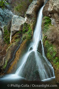
Darwin Falls in Death Valley, near the settlement of Panamint Springs. The falls are fed by a perennial stream that flows through a narrow canyon of plutonic rock, and drop of total of 80' (24m) in two sections.
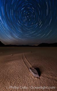
Racetrack sailing stone and star trails. A sliding rock of the Racetrack Playa. The sliding rocks, or sailing stones, move across the mud flats of the Racetrack Playa, leaving trails behind in the mud. The explanation for their movement is not known with certainty, but many believe wind pushes the rocks over wet and perhaps icy mud in winter
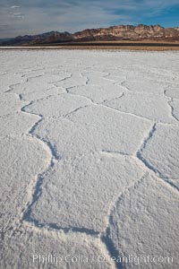
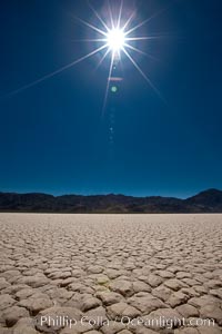
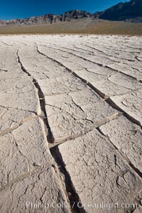
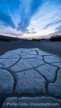
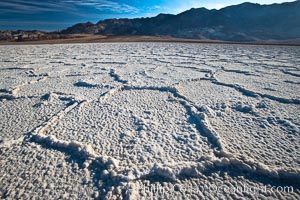
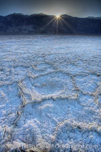
Salt polygons. After winter flooding, the salt on the Badwater Basin playa dries into geometric polygonal shapes.
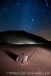
Racetrack sailing stone and Milky Way, at night. A sliding rock of the Racetrack Playa. The sliding rocks, or sailing stones, move across the mud flats of the Racetrack Playa, leaving trails behind in the mud. The explanation for their movement is not known with certainty, but many believe wind pushes the rocks over wet and perhaps icy mud in winter
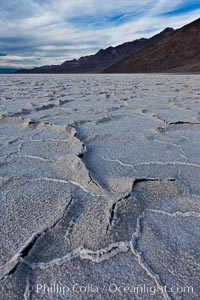
Salt polygons. After winter flooding, the salt on the Badwater Basin playa dries into geometric polygonal shapes.
Eureka dune grass, and rare and federally endangered species of grass endemic to the Eureka Valley and Eureka Sand Dunes. The Last Chance mountains, lit by sunset, as visible in the distance. Swallenia alexandrae, a perennial grass, grows only in the southern portion of Eureka Valley Sand Dunes, in Inyo County, California.
Hardened mud playa and sand dunes, dawn, Mesquite dunes.
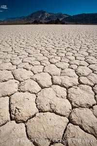
Racetrack Playa, an ancient lake now dried and covered with dessicated mud.
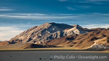
Sunset over the Racetrack Playa. The Cottonwood Mountains rise above the flat, dry, ancient lake bed.
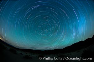
Star trails, rotating around the North Star (Polaris), seen from Death Valley.
Eureka Dunes. The Eureka Valley Sand Dunes are California's tallest sand dunes, and one of the tallest in the United States. Rising 680' above the floor of the Eureka Valley, the Eureka sand dunes are home to several endangered species, as well as ""singing sand"" that makes strange sounds when it shifts. Located in the remote northern portion of Death Valley National Park, the Eureka Dunes see very few visitors.
Eureka Dunes. The Eureka Valley Sand Dunes are California's tallest sand dunes, and one of the tallest in the United States. Rising 680' above the floor of the Eureka Valley, the Eureka sand dunes are home to several endangered species, as well as ""singing sand"" that makes strange sounds when it shifts. Located in the remote northern portion of Death Valley National Park, the Eureka Dunes see very few visitors.
Eureka Dunes. The Eureka Valley Sand Dunes are California's tallest sand dunes, and one of the tallest in the United States. Rising 680' above the floor of the Eureka Valley, the Eureka sand dunes are home to several endangered species, as well as ""singing sand"" that makes strange sounds when it shifts. Located in the remote northern portion of Death Valley National Park, the Eureka Dunes see very few visitors.
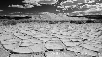
Arid and barren mud flats, dried mud, with the tall Eureka Dunes in the distance.
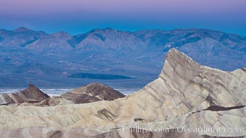
Zabriskie Point, sunrise. Manly Beacon rises in the center of an eroded, curiously banded area of sedimentary rock, with the Panamint Mountains visible in the distance.
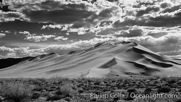
Eureka Dunes. The Eureka Dunes are California's tallest sand dunes, and one of the tallest in the United States. Rising 680' above the floor of the Eureka Valley, the Eureka sand dunes are home to several endangered species, as well as ""singing sand"" that makes strange sounds when it shifts.
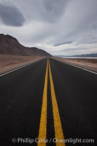
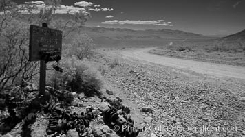
Lonely road, Death Valley.
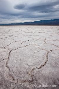
Salt polygons. After winter flooding, the salt on the Badwater Basin playa dries into geometric polygonal shapes.
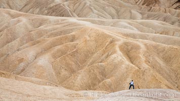
Eroded hillsides near Zabriskie Point and Gower Wash.
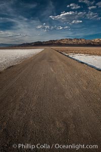
West Side Road cuts across the Badwater Basin.
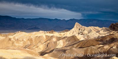
Sunrise at Zabriskie Point, Manly Beacon is lit by the morning sun while dark clouds lie on the horizon.
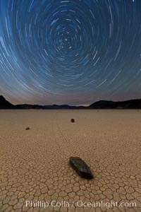
Racetrack sailing stone and star trails. A sliding rock of the Racetrack Playa. The sliding rocks, or sailing stones, move across the mud flats of the Racetrack Playa, leaving trails behind in the mud. The explanation for their movement is not known with certainty, but many believe wind pushes the rocks over wet and perhaps icy mud in winter
A sliding rock of the Racetrack Playa. The sliding rocks, or sailing stones, move across the mud flats of the Racetrack Playa, leaving trails behind in the mud. The explanation for their movement is not known with certainty, but many believe wind pushes the rocks over wet and perhaps icy mud in winter.
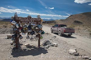
Teakettle Junction, on the notorious road to the Racetrack Playa.
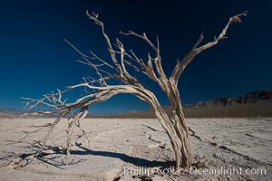
Dried tree and barren, arid mud flats, Eureka Valley.
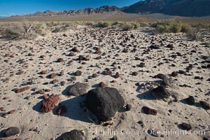
Volcanic debris, small lava rocks scattered about the Eureka Valley.
Sunset on the Last Chance Mountain Range, seen from Eureka Valley Sand Dunes.
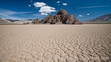
The Grandstand, standing above dried mud flats, on the Racetrack Playa in Death Valley.
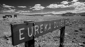
Sign to Eureka Dunes and Eureka Valley.
Dawn, Zabriskie Point.
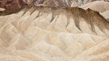
Eroded hillsides near Zabriskie Point and Gower Wash.
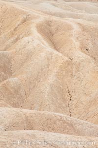
Eroded hillsides near Zabriskie Point and Gower Wash.
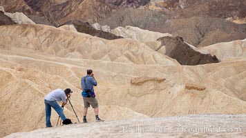
Eroded hillsides near Zabriskie Point and Gower Wash.
Zabriskie Point sunrise, clouds blurred by long time exposure, Death Valley National Park, California.
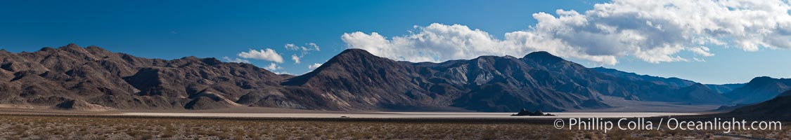
Panorama of the Racetrack at Death Valley.
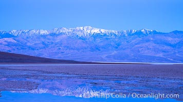
Sunrise lights Telescope Peak as it rises over the salt flats of Badwater, Death Valley. At 11,049 feet, Telescope Peak is the highest peak in the Panamint Range as well as the highest point in Death Valley National Park. At 282 feet below sea level, Badwater is the lowest point in North America.
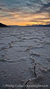
Salt polygons. After winter flooding, the salt on the Badwater Basin playa dries into geometric polygonal shapes.
Sunrise at Zabriskie Point, Manly Beacon is lit by the morning sun while clouds from a clearing storm pass by.
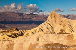
Sunrise at Zabriskie Point, Manly Beacon is lit by the morning sun while clouds from a clearing storm pass by.
Devils Golf Course, California. Evaporated salt has formed into gnarled, complex crystalline shapes in on the salt pan of Death Valley National Park, one of the largest salt pans in the world. The shapes are constantly evolving as occasional floods submerge the salt concretions before receding and depositing more salt.
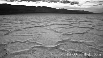
Salt polygons. After winter flooding, the salt on the Badwater Basin playa dries into geometric polygonal shapes.
Devils Golf Course. Evaporated salt has formed into gnarled, complex crystalline shapes on the salt pan of Death Valley National Park, one of the largest salt pans in the world. The shapes are constantly evolving as occasional floods submerge the salt concretions before receding and depositing more salt.
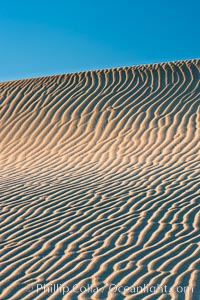
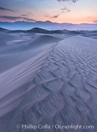
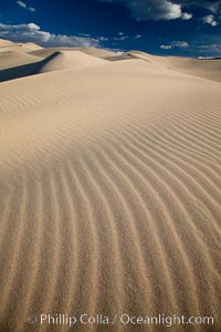
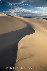
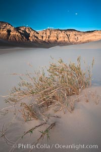
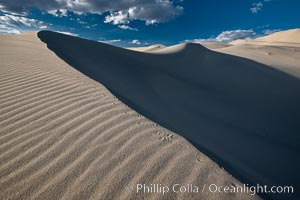
Ripples in sand dunes at sunset, California. Winds reshape the dunes each day. Early morning walks among the dunes can yield a look at sidewinder and kangaroo rats tracks the nocturnal desert animals leave behind.
Sand Dunes, California. Near Stovepipe Wells lies a region of sand dunes, some of them hundreds of feet tall.
Crankshaft junction.
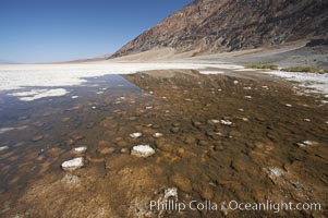
Badwater, Death Valley. A spring feeds this small pool year round. The water is four times more saline than ocean water. The small Badwater snail (Assiminea infima) is found only in Death Valley, in spring-fed pools such as these, and is threatened by habitat destruction. At 282 feet below sea level, Badwater is the lowest point in North America.
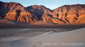
Sand Dunes and the Grapevine Mountains, California. Near Stovepipe Wells lies a region of sand dunes, some of them hundreds of feet tall.