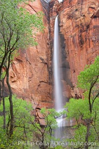
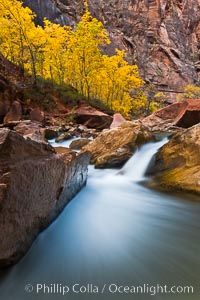
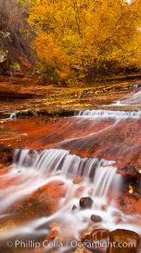
Waterfall at Temple of Sinawava during peak flow following spring rainstorm. Zion Canyon.
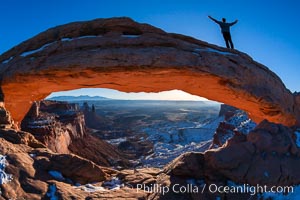
Atop Mesa Arch, Canyonlands National Park, Utah
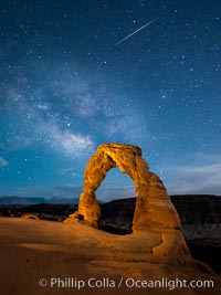
Milky Way galaxy and a Shooting Star over Delicate Arch at Night
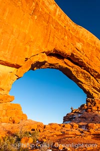
Hiker in North Window, sunset, western face. North Window is a natural sandstone arch 90 feet wide and 48 feet high. Arches National Park, Utah.
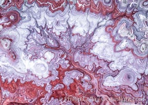
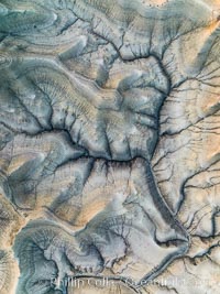
The Tree of Eons, a spectacular dendritic formation in the Bentonic Hills of Utah. Fantastic colorful sedimentary patterns, ancient Bentonite layers are exposed through erosion in the Utah Badlands. The Bentonite Hills are composed of the Brushy Basin shale member of the Morrison Formation. This layer was formed during Jurassic times when mud, silt, fine sand, and volcanic ash were deposited in swamps and lakes. Photographed just before sunrise with soft pre-dawn illumination. Aerial panoramic photograph.
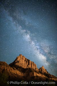
Milky Way over the Watchman, Zion National Park. The Milky Way galaxy rises in the night sky above the the Watchman.
A hiker greets the dawn, with Turret Arch in the distance viewed through North Window at Sunrise
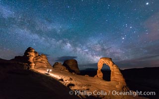
Light Painting Delicate Arch with Stars and the Milky Way
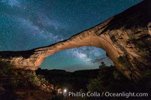
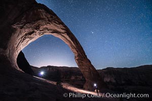
Owachomo Bridge and Milky Way. Owachomo Bridge, a natural stone bridge standing 106' high and spanning 130' wide,stretches across a canyon with the Milky Way crossing the night sky.
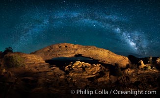
Panorama of the Milky Way over Mesa Arch.
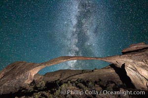
Landscape Arch and Milky Way, Arches National Park, Utah
The Virgin River flows by autumn cottonwood trees, part of the Virgin River Narrows. This is a fantastic hike in fall with the comfortable temperatures, beautiful fall colors and light crowds.
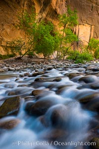
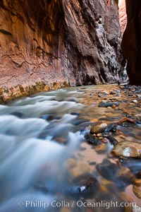
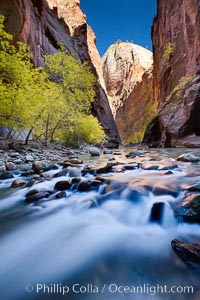
The Virgin River Narrows, where the Virgin River has carved deep, narrow canyons through the Zion National Park sandstone, creating one of the finest hikes in the world.
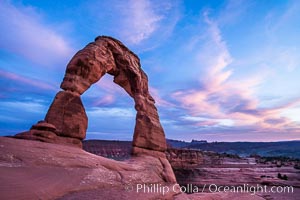
Delicate Arch at Sunset, Arches National Park
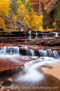
Archangel Falls in autumn, near the Subway in North Creek Canyon, with maples and cottonwoods turning fall colors.
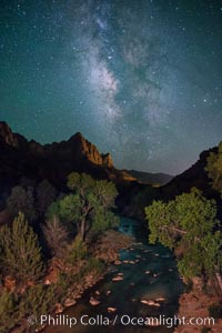
Milky Way over the Watchman, Zion National Park. The Milky Way galaxy rises in the night sky above the the Watchman.
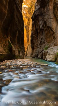
The Virgin River Narrows, where the Virgin River has carved deep, narrow canyons through the Zion National Park sandstone, creating one of the finest hikes in the world.
Dawn over the Skyline Rim, Factory Bench and Lower Blue Hills, Utah. The Henry Mountains are in the distance.
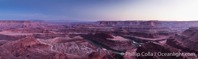
Sunset at Dead Horse Point Overlook, with the Colorado River flowing 2,000 feet below. 300 million years of erosion has carved the expansive canyons, cliffs and walls below and surrounding Deadhorse Point
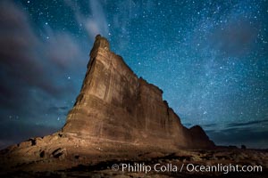
Stars over the Tower of Babel, Arches National Park, Utah
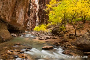
The Virgin River flows by autumn cottonwood trees, part of the Virgin River Narrows. This is a fantastic hike in fall with the comfortable temperatures, beautiful fall colors and light crowds.
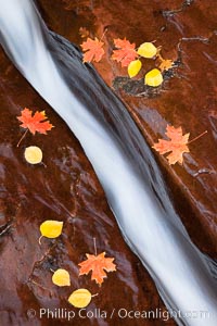
Water rushes through a narrow crack, in the red sandstone of Zion National Park, with fallen autumn leaves.
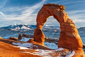
Delicate Arch, dusted with snow, at sunset, with the snow-covered La Sal mountains in the distance. Delicate Arch stands 45 feet high, with a span of 33 feet, atop of bowl of slickrock sandstone.
Molly's Castle, aerial view, Goblin Valley State Park. Curtis Formation whiteish caprock is on top, with reddish Entrada Sandstone below, both of Jurassic era. Molly's castle lies in the San Rafael desert near Goblin Valley, and drains into the Colorado River watershed. Aerial panoramic photograph.
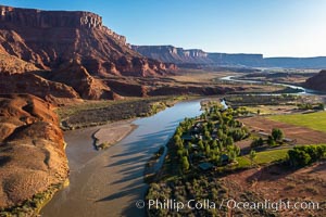
Colorado River and Sorrel River Ranch, Moab, Utah. The Dome Plateau rises over the river on the left.
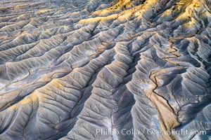
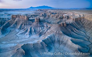
Erosion patterns in the Utah Badlands, aerial abstract photo.
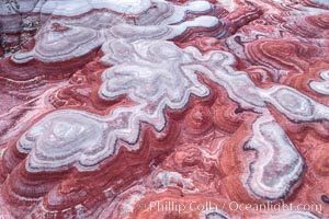
Fantastic colorful sedimentary patterns of Bentonite layers, seen as striations exposed in the Utah Badlands. The Bentonite Hills are composed of the Brushy Basin shale member of the Morrison Formation formed during Jurassic times when mud, silt, fine sand, and volcanic ash were deposited in swamps and lakes into layers, now revealed through erosion. Aerial photograph.
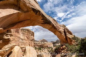
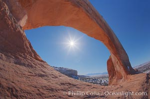
Hickman Bridge, Capitol Reef National Park
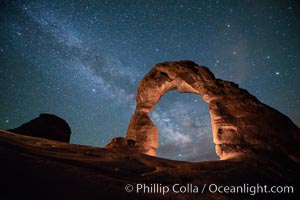
Milky Way and Stars over Delicate Arch, at night, Arches National Park, Utah
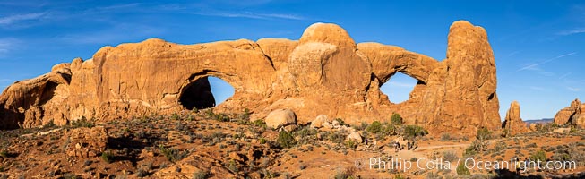
The Windows at sunset, Arches National Park
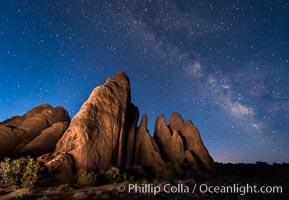
Milky Way over Sandstone Fins. Sandstone fins stand on edge. Vertical fractures separate standing plates of sandstone that are eroded into freestanding fins, that may one day further erode into arches.
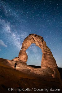
Delicate Arch and Milky Way, lit by quarter moon, hiker's flashlight and the fading blue sky one hour after sunset. Arches National Park, Utah.
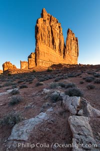
The Organ at sunrise, Courthouse Towers, Arches National Park
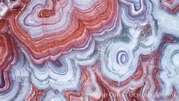
Fantastic colorful sedimentary patterns, Bentonite layers are seen as striations exposed in the Utah Badlands, part of the Chinle Formation formed during the Upper Triassic Period. Aerial photograph.
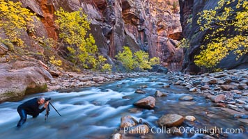
Photographer in the Virgin River Narrows, with flowing water, autumn cottonwood trees and towering red sandstone cliffs.
The Virgin River flows through the Zion Narrows, with tall sandstone walls towering hundreds of feet above.
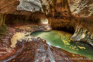
The Subway, a iconic eroded sandstone formation in Zion National Park.
Yellow cottonwood trees in autumn, fall colors in the Virgin River Narrows in Zion National Park.
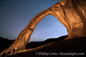
Stars over Corona Arch at Night, Moab, Utah
Owachomo Bridge and Milky Way. Owachomo Bridge, a natural stone bridge standing 106' high and spanning 130' wide,stretches across a canyon with the Milky Way crossing the night sky.
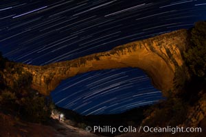
Owachomo Bridge and Star Trails, at night. Owachomo Bridge, a natural stone bridge standing 106' high and spanning 130' wide,stretches across a canyon with the Milky Way crossing the night sky.
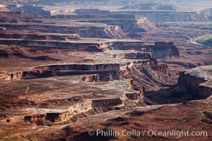
Soda Springs Basin from Green River Overlook, Island in the Sky, Canyonlands National Park, Utah.
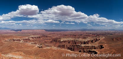
Canyonlands National Park panorama.
Landscape Arch and Milky Way, stars rise over the arch at night.
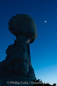
Balanced Rock and Moon at night, Arches National Park
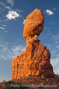
Balanced Rock, a narrow sandstone tower, appears poised to topple.
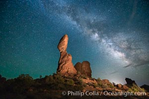
Balanced Rock and Milky Way stars at night.
Wilson Arch, Utah
Small waterfalls and autumn trees, along the left fork in North Creek Canyon, with maple and cottonwood trees turning fall colors.
Lower Blue Hills Badlands, sunrise, Utah
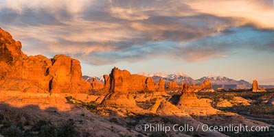
Sunset over Garden of the Gods, Arches National Park
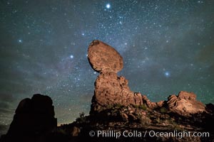
Moon and Stars over Balanced Rock, Arches National Park
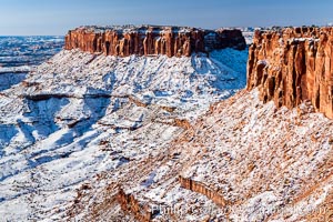
Canyonlands National Park, winter, viewed from Grandview Point. Island in the Sky.
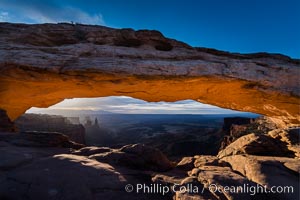
Mesa Arch Sunrise, Canyonlands National Park, Utah
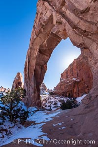
Pine Tree Arch, Arches National Park.
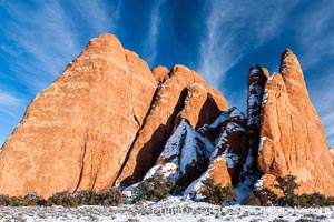
Sandstone fins. The vertical slabs of Entrada sandstone may become natural sandstone arches.
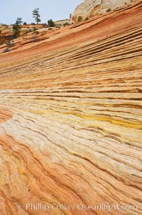
Navajo sandstone forms the cliffs and walls of Zion National Park. The sandstone reaches a thickness of 2300 feet and consists of ancient cemented desert sand dunes. Horizontal lines, commonly called crossbedding, represent layers of wind-blown sand that built up into sand dunes. These dunes were then buried, and the sand grains glued together by calcite and iron oxide to form sandstone.
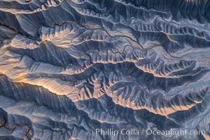
Erosion patterns in the Utah Badlands, aerial abstract photo.
Stars over Corona Arch at Night, Moab, Utah
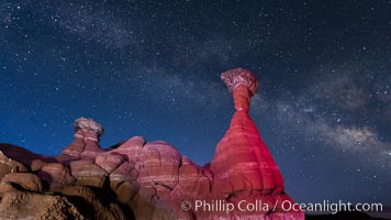
Milky Way and Toadstool Hoodoos, Grand Staircase - Escalante National Monument.
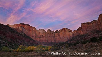
West Temple, The Sundial and the Altar of Sacrifice lit by soft alpenglow, about 20 minutes before sunrise.
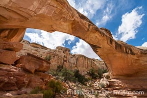
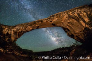
Hickman Bridge, Capitol Reef National Park. A natural bridge formed by water eroding it from below, Hickman Bridge is one of the most spectacular and easily accessible natural bridges in the United States.
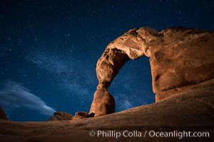
Milky Way arches over Delicate Arch, as stars cover the night sky.
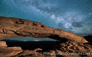
The Milky Way arching over Mesa Arch at night.
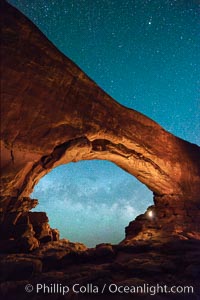
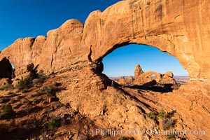
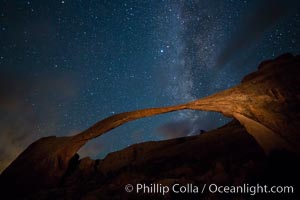
Milky Way through North Window, Arches National Park
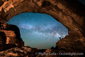
Hiker and Milky Way through North Window, Arches National Park
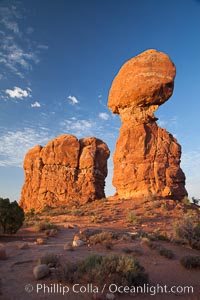
Balanced Rock, a narrow sandstone tower, appears poised to topple.
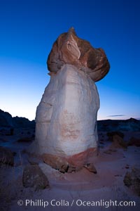
Toadstool Hoodoos near the Paria Rimrocks.
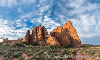
Sandstone fins stand on edge. Vertical fractures separate standing plates of sandstone that are eroded into freestanding fins, that may one day further erode into arches.
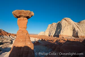
Toadstool Hoodoos near the Paria Rimrocks.
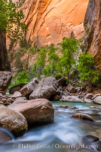
The Virgin River Narrows, where the Virgin River has carved deep, narrow canyons through the Zion National Park sandstone, creating one of the finest hikes in the world.
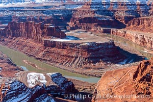
Dead Horse Point Overlook, with the Colorado River flowing 2,000 feet below. 300 million years of erosion has carved the expansive canyons, cliffs and walls below and surrounding Deadhorse Point.

Inflatable cop. Kanab's Finest, hard at work. A Kanab police officer actively enforcing the speed limit in the town of Kanab, Utah.